
Engineering projects demand meticulous planning and extensive data management to ensure they are carried out efficiently and effectively. At Benchmark, our skilled team provides cutting-edge 3D utilities modeling services that shed light on the underground infrastructure of your site. Leveraging the latest technologies, we convert collected spatial data and imagery into practical visualizations that enhance your team’s ability to refine operational processes.
At Benchmark, we provide 3D modeling services that are crafted to meet the unique demands of your project. We strive to serve as your reliable partner, supplying top-tier data supported by professional guidance. Our experience spans multiple industries, allowing us to create specialized models that cater to the distinct needs of each client. Entrust us with your data management needs so you can concentrate on the core activities of your business.
Sectors like construction, mining, urban development, and telecommunications rely heavily on detailed utility mapping to fully understand site conditions and manage underground hazards effectively. It’s crucial for professionals in these areas to comprehend the subsurface arrangements to avoid accidental disruptions to essential services such as electrical lines, water pipes, or communication cables. These disruptions can cause extensive financial loss, safety risks, environmental damage, or delays in project timelines. Detailed utility maps provide crucial information about various underground elements including:
Understanding the above-ground features of your project site is only half the battle. Utility data visualizations are essential tools that offer valuable insights into subsurface elements, which can significantly impact the success of your project. Before creating any 3D model, the first step is to define your project scope and specific needs. Identify the type of information you require, which will guide a more targeted and efficient data collection process. With a clearer understanding of your information needs, you can make well-informed decisions to develop effective 3D utility models.
The initial data collection process starts with reviewing existing site records, as-built drawings, and historical maps. Once on-site, surveying professionals use a variety of technologies and software to create an accurate subsurface visualization. Electromagnetic induction (EMI) is a commonly employed technique to detect objects across different soil types and terrains. This method uses transmitters to send low-frequency electrical currents, generating magnetic fields that interact with existing ones. A receiver then traces the position and depth of these objects, providing valuable data for the project.
For precise analysis, the collected subsurface data must be imported into specialized software to facilitate effective investigation and interpretation for informed decision-making.
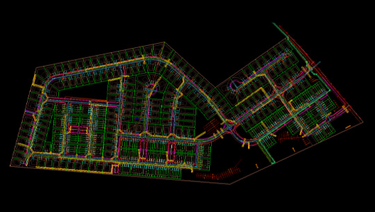
Advanced tools such as CAD programs and geospatial information systems (GIS) software allow professionals to consolidate all data into a single, user-friendly platform, streamlining the workflow for better organization and cost-efficiency. Once imported, technicians can define point and area features, add tags, create layers for GPR and EMI locator data, and log all field activities. This enables the analysis of complex geometry and the extraction of valuable insights regarding the position and depth of subsurface elements, leading to more successful project outcomes.
Streamline and visualize your complex projects with Benchmark’s 3D utilities modeling services. With over 30 years as a leader in data services, we are committed to optimizing workflows and propelling your operations toward success.
Our team, comprised of licensed engineers, surveyors, and technicians, adapts to projects of any scope across various industries, ensuring data is tailored to your specifications. Equipped with the latest tools and state-of-the-art software, Benchmark delivers precision and efficiency in every project. Our innovative approach and extensive infrastructure enable us to complete over 1,000 jobs annually, positioning us as one of the most cost-effective and reliable service providers in the industry.
© 2024 All Rights Reserved
All right reserved Benchmark